In these days of uncertainty, we continue working on GIMS project. Our hopes for this project to become a real product shortly ready for the market are high!
Elisabetta Giromini – ComoNExT – interviewed Ela Šegina, Project Manager for GIMS at the Slovenian Institute of Geology, responsible for the installation on field of GIMS units in two spots subject to landslides in Slovenia. She confirmed that results are really encouraging! For more details read the interview below.
Q. What new/more accurate information you get from GIMS unit about the landslides movements?
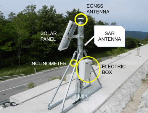
A. I would expose the good spatial resolution of the landslide movement that they provide. This is due to their compact and small construction that allows installation on even remote, rather inaccessible areas of particular interest. Due to the low price, it is possible to install several units in the form of a network that covers the entire landslide.
Q. What is the utility of this information for the monitoring activity?
A. With good spatial coverage, we get insight into the internal dynamics of the landslide body mass as a whole which is very important at understanding landslide processes and helps at predicting its behaviour.
Q. How can this be of use for authorities/civil protection in Slovenia?
A. Comparing to other techniques, for example, wire crackmeter, GIMS is a low-cost solution. Price, rather simple installation and comparable results make this method available to civil protection. It could be used for monitoring previously detected hotspots, based on which the mitigation plans could be developed.
Q. Is there any room for improvement about GIMS units?
A. Some further work should be done regarding the energy supply as the location in the mountainous area requires higher energy capacity due to the common bad weather. The interruption of the transmission occurring right during the periods with the most intensive movements disables the continuous monitoring during the most critical periods. Also, increased time resolution would result in more precise rainfall thresholds determination.
Q. Would you recommend this system to other Geological Survey Services?
A. Definitely yes. They are small, compact, robust enough, mobile, easy to install, low-cost, exhibit results well-comparable to other techniques but with increased spatial resolution.
The last months of project implementation will be dedicated to overcome the last criticisms and refine the GIMS station both for the hardware and software.
Below you can see a graph – kindly shared by Ela – showing the correlation of the displacement measured with GIMS, a testing technique (wire crackemeter) and the precipitation for the given period.
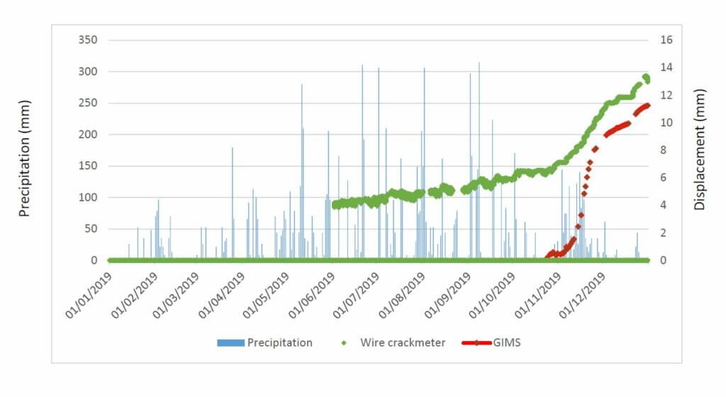
It is possible to observe that both instruments that are located in the proximity measured the considerable displacement during the rainy period in November. The data was acquired on study site 2 (Potoška planina, namely Urbas landlside).